Deterring Crime
Through
Tactical Design
Table of Contents
Table of Contents
- Abstract
- Purpose
- Problem
- Objective
- Motivation
- Context
- Composition
- Crime
- Literature Review
- Origin
- Evolution
- Application
- Critique
- Methodology
- Outline
- Research
- Fieldwork
- Site Improvement
- Results
- Assessment
- Analysis
- Implications
- Recommendations
- Implementation
- Conclusion
- Critique
- Reflection
- Bibliography
- Appendices
Abstract
Crime Prevention Through Environmental Design (CPTED) is an alternative approach to deterring criminal behavior through the application of interdisciplinary design principles within the natural and built environment. This project seeks to pair particular CPTED principles to site-specific residential deficiencies within the neighborhood north of the University of Washington’s Seattle campus. Currently, there is a procedural disconnect between the ideologies of CPTED and their application to existing neighborhoods and criminalities. To effectively merge the gap, this project establishes an evaluation process and develops a corresponding blueprint for changes to be made within the study area. To achieve this end, the project follows three distinct phases comprised of research, fieldwork, and site improvement. Specifically, this scheme uses crime statistics and gauged community perspective to guide street segment evaluations based on predominant components of CPTED. From this assessment, corresponding recommendations are deduced to provide an array of relevant principles to aid in the deterrence of crime. The final product is a report detailing the diagnoses of deficiencies in coordination with a set of recommendations scaled to the parcel and neighborhood level. By aiming the analysis and prescription of principles to the local community, this project functions as a preliminary case study for comprehensible CPTED implementation. Components of CPTED can be readily employed within personal properties, offering an alternative to increased police presence and defensive target hardening, while supporting the development of safer communities and public spaces.
Purpose
Problem:
This project is structured to address the disconnect between the theory of Crime Prevention Through Environmental Design (CPTED) and the particular criminal realities facing individual neighborhoods. The driving force behind the concept of CPTED is to influence public social behavior through intentional design alterations. However, CPTED principles are often only discussed using generalized frameworks, neglecting to demonstrate actualized interventions that respond to independent neighborhood’s composition or criminal tendencies. Therefore, this project seeks to ground the ideology of CPTED in site specific characteristics in order to make the application of its principles more comprehensible to local communities.
Objective:
This project seeks to enlighten and empower communities with small tactical design interventions that work to deter criminal behavior at the neighborhood level. To accomplish this task, this project will explore and evaluate the potential of CPTED principles within a residential neighborhood; in order to recommend design implementations for the community to enact that work to improve current conditions and positively influence socio-spatial behavior. Ultimately, this project is attempting to exhibit the prospective of CPTED as a crime prevention strategy, through procedurally linking its’ principles to current neighborhood conditions and packaging the resulting information for community action.
Motivation:
I have chosen to focus my study on the intersection of crime and design because it pertains to my current academic interests and future professional pursuits. Within the major of Community, Environment, and Planning, I am predominantly interested in urban design and community development. This project grants me the opportunity to bring these interests together by exploring a specific concept within urban design and engaging local residents with the goal of positively impacting the safety of their neighborhood. Additionally, this project offers me the prospect of assessing my skills as a planner; effectively testing my planning toolbox in regards to analyzing a communities’ needs and responding through research, fieldwork, and resolutions. Moreover, this project may also play a critical role in helping me understand my strengths, weaknesses, interests, and disinterests within my current career pathway as an Urban Planner; helping to guide my future focus when applying to graduate programs within different aspects of the field of planning.
Although motivated by my studies, interests, and career path, I was inspired to address this particular issue by the community I have been a part of for the past four years. I have lived in the neighborhood just north of the University of Washington’s campus for my entire collegiate career and have personally witnessed both the abundance of crime and safety issues that are rooted here as well as the lack of structural change or community organizing. Criminal occurrences have seemingly become commonplace around the University District and it is extremely disheartening to see the effects on the vitality of the area. Personally, I’ve read the flood of UW Alerts we receive about local crime, I’ve felt uncomfortable traversing the region, and I’ve even had my home broken into. These are common themes shared amongst the residents of the community, however because this area experiences such rapid turnover, it’s challenging to garner enough support to address these issues head on. Consequently, before graduating and leaving the area myself, I wanted to assure that some sort of positive impact resulted from my investigation. I felt as though the best way to achieve this outcome would be to target the Husky Neighborhood Internship program as the recipient of my inquiry. Currently employed as a Husky Neighborhood Intern myself, engaged in community improvement projects, I understand the value in passing down this information in order to facilitate changes over time. Therefore, my motivation for this project is twofold, through my academic interests and career pathway as well as my personal connection and investment in the long term welfare of the community.
Context
Composition:
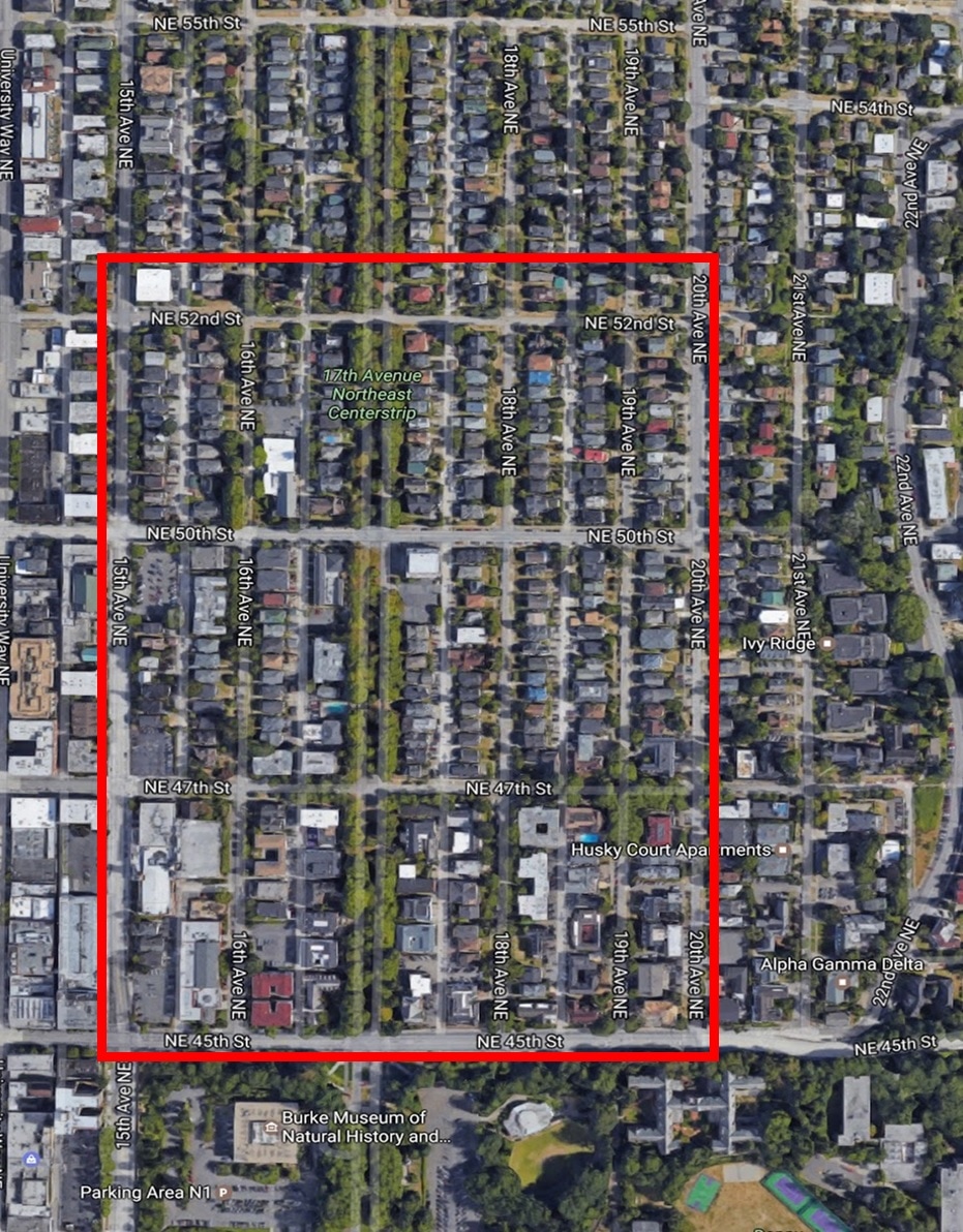
The specific area of focus for this project is the North of 45th Neighborhood, located just north of the University of Washington’s Seattle Campus. The general boundaries that delineate this neighborhood are Ravenna Park to the north, UW’s campus to the south, University Village to the east, and the Ave’s Commercial Corridor to the west. In order to narrow my scope, the precise study area for this project is confined to a three-block sample along the neighborhoods southernmost border (Appendix A). However, in its entirety, this neighborhood encompasses nearly all of the UW Greek System, which accounts for 70 fraternities and sororities and approximately 4,000 students. In addition, this neighborhood is the home of 161 single family residences and 134 dual family residences, which house both permanent residents and student renters. This unorthodox collection of living situations creates a very complex public dynamic, which is further complicated by the shared spatial usage from religious organizations, homeless populations, and other members of the public. This neighborhoods’ close proximity to several socioeconomic hotspots makes this space extremely accessible to a very large group of people, not directly living within the neighborhood or affiliated with the University. The transitory nature of this neighborhood, grounded upon both the daily mobility of users and the annual conversion of living situations couple to define an area permanently in flux; contextual factors which may play a prominent role in the abundance of crime and lack of communal change that has plagued this neighborhood.
Crime:
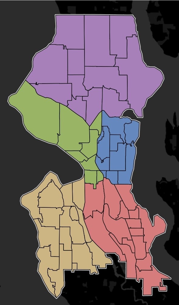
Expanding the scale, the North of 45th Neighborhood is currently situated within one of the worst districts in regards to crime rates. The Seattle Police Department divides the greater Seattle region into five precincts and within each precinct, they again divide the area into Micro Community Policing Plans (MCPP). The North of 45th Neighborhood is located within the north precinct and belongs to the University MCPP (Appendix B). Though the University MCPP encompasses more land than just the North of 45th Neighborhood, this zone as a whole has been the site of rapes, aggravated assaults, larceny, burglaries, and car theft, totaling to 14,187 separate incidents since the year 2008. This number of criminal occurrences is in stark contrast to the surrounding northern MCPP’s of Sandpoint and Wallingford, totaling 7,636 and 7,208 criminal incidents respectively. In addition, over the past 8 years, crime has steadily increased each year. Although the cause and effect behind these trends are not within the scope of this project, these statistics offer a base of criminal knowledge to contextualize my investigation.
As a neighborhood situated within a Micro Community with such high rates of crime, measures must be taken to address these burdens. However, these needs have only been met by jurisdictional mitigations which established a joint task force between the Seattle and University Police Departments to consistently patrol the area. As evidenced by the aforementioned crime data, criminal behavior has not been inhibited by the increased police presence. This unresponsiveness demands alternative solutions to decreasing criminal activity, opening the door for elements of Crime Prevention Through Environmental Design. Thus, setting the stage for a CPTED site analysis to be completed, establishing a procedural road map to help the immediate stakeholder pool of fraternities, sororities, student renters, permanent residents, community councils, churches, and university take ownership of their environment and improve their neighborhood.
Literature Review
My senior project is concentrated on the concept of Crime Prevention Through Environmental Design. Crime Prevention Through Environmental Design (CPTED) is a planning concept that utilizes strategic design elements within the natural and built environment to deter criminal behavior. The neighborhoods in which we live, our communal built environment, are subject to a multitude of factors that may increase criminal activity and decrease community safety. Local governments often neglect these issues due to a lack of financial support and an inability to make critical infrastructure modifications. I chose to focus my project on the principles of CPTED as it offers a platform for meaningful changes to take place, on an adequate scale, and that work toward preventing criminal behavior from rooting itself in neighborhoods. Through this project, I intend to demonstrate how elements of CPTED can be implemented within communities to strategically address a wide range of environmental characteristics in order to combat various instances of criminal activity. The purpose of this literature review is to thoroughly explain the concept of Crime Prevention Through Environmental Design and to provide substantial supporting information on the expanse of its’ uses. My review of the literature is structured into four primary sections; the origin, evolution, application, and critique of CPTED.
Origin:
To understand the origin of Crime Prevention Through Environmental Design, I began my research by tracing back CPTED’s founding principles. However, one true origin point is difficult to define, as the concepts of CPTED have been linked as far back as the mid twentieth century from the individual works of Elizabeth Wood and Jane Jacobs. Together, these CPTED forbearers helped established concepts of their own that would go on to be developed into a more comprehensive framework, pairing crime prevention and design. As this project will not limit itself to one particular conceptualization of CPTED theory, this literature review will explore, analyze, and utilize differing theories and strategies of such notions that have been built upon and improved throughout the decades.
To begin, Elizabeth Wood, the Executive Director of the Chicago Housing Authority, “was one of the prime advocates of the importance of physical design considerations in achieving social objectives” (Jusiewics 12). She believed that in order to effectively combat crime, the quality of life of local residents must be significantly enhanced. In the 1940’s, as the Public Works Administration constructed massive, racially integrated, public housing complexes across the nation; Wood “strove to make the surrounding residential environments of lower class citizens more rich and fulfilling” (Jusiewics 12). She undertook this task through developing design guidelines to improve security and increase aesthetics. The most prevailing design theories developed by Elizabeth Wood, were natural residential surveillance and informal social control. These concepts helped shape the idea that areas utilized and observed by residents were areas under control and effectively restrictive of criminal opportunity. Although her notions were never truly actualized, similar concepts are found and refined within the core of Jane Jacobs’ ideology.
Over two decades later in the 1960’s, Jane Jacobs put forth principles centered upon the idea of creating consistently active and diversely used public space. In her book, The Death and Life of Great American Cities, she states that the “ubiquitous principle is the need of cities for a most intricate and close-grained diversity of uses that give each other constant mutual support” (Jacobs 14). In relation to crime prevention, her theories promote mixed uses, well-activated and supported spaces, and high and frequent pedestrian usage. These ideas, similar to Elizabeth Wood, all reinforce the notion that informal surveillance will reduce crime. However, as Wood visualized these ideals in public housing units, Jacobs called for their enactment across cities. My project will pull from both of these scales, placing significant emphasis on the ideals of activation and surveillance, in order to foster a safer and more controlled community environment. Theses notable base concepts, responding to the need for positive social influence from the built environment, provided a strong platform for the development of a new design framework, one compiled and advanced a decade later.
Evolution:
The recognized formulation of the comprehensive idea of CPTED was established in the 1970’s and is predominantly accredited to criminologist C. Ray Jeffery. Jeffery coined the terminology of Crime Prevention Through Environmental Design, as it was the title of his published book, expounding the idea that crime prevention should focus on biological and environmental influences. Jeffery’s work was notable as it was a “departure from the traditional target hardening approach, i.e. preventing break-ins by locks on doors, bars on windows, etc., to concentrating instead on human behavior and planning principles” (Jusiewics 11). His book, though presenting a major shift in the paradigm of criminology, was strongly opposed and neglected as his biological argument was denounced. Jeffery posited that “criminologists and sociologists had put too much value on the social causes of crime” and instead wanted to focus on “factors related to the biology of crime and reducing the environmental opportunities for crime (Clarke 1). His book provided very few real design recommendations to alter environments, however, Jeffery helped set the stage for an alternative mode of crime prevention.
During the same time C. Ray Jeffery’s book was published and disputed, Architect Oscar Newman was at work criticizing public housing and promulgating his ideas on defensible space. Newman’s main concept of defensible space revolved around the idea that communities could defend their neighborhoods by taking ownership and responsibility of space and effectively isolating criminal activity. Comparable to Jeffery, Newman believed that high rates of crime were stemming from environmental factors such as layout, scale, and site design. Though particularly attentive to American public housing or project housing, Newman put forth design standards with the goal of “creating environments which reduce the opportunities for crime while encouraging people to use public space in ways that contribute to their safety and enhance their sense of community” (Jusiewics 16). Within his book, Creating Defensible Space, Newman posits that the intent and creation of defensible spaces was to “enable residents to take control of their neighborhoods, to reduce crime, and to stimulate private reinvestment” through relying on “self-help rather than on government intervention” (Newman 9). My project relates well in this regard as my suggestions will demonstrate various components of CPTED that community members can implement themselves, rather than requiring city intervention. Ultimately, Newman developed defensible principles that were based strongly on the ownership and territoriality of space. Furthermore, he applied designs that eliminated public spaces, assigned specific uses to sites, kept areas dominated by residential units, and limited access to non-residents. Newman proposed these ideals with the supporting rationale: by dissolving public areas where crime tended to breed, promoting personalization and family usage, and limiting access, criminal operating opportunities would be significantly reduced. Similar to Jeffery, his “thesis was savagely criticized by criminologists and other social scientists, who accused him of environmental determinism and of making simplistic extrapolations to human behavior from territorial behavior of animals” (Clarke 2). In response, Newman and Jeffery would agree that environmental determinism, the belief that the physical environment directly predisposes certain behavior, does play a significant role. They were agents of change and were transitioning the fields of crime prevention and planning towards this idea; however they didn’t believe that environmental conditions were the sole determinants. Despite the mass opposition, Newman’s work resulted in positive attention from the federal government and major design changes to tower-block types of public housing.
The culmination of the aforementioned ideas were formalized and publicized by Timothy Crowe in the 1990’s. A follower of C. Ray Jeffery, Crowe further developed his predecessors’ ideals into a complete prescribed set of principles to help guide police, architects, and planners. Crowe helped define the basic ideology behind CPTED by expounding that the “proper design and effective use of the built environment can reduce the fear and incidence of crime and thereby improve the overall quality of life” (Crowe 1). Crowe clearly separated his approach from Newman through enlightening the public that crime prevention did not demand walls, defense, and isolation, but rather required a high-quality aesthetic built environment. Crowe consistently preached that strategic design was the most effective preventative measure and helped formalize the aforementioned concepts of Wood, Jacobs, and Newman into three distinct approaches: natural access control, natural surveillance, and territorial behavior. Regarding Wood and her ideas on social spatial control, Crowe provided specific methods to ensure access control such as “doors, shrubs, fences, gates, and other physical design elements to discourage access to an area by all but its intended users” (Crowe 1). Addressing the importance of informal surveillance, as made famous by Jacobs, Crowe illustrated that surveillance can be “enhanced by providing adequate lighting, intentional window placement, and landscaping that allows for unobstructed views” (Crowe 1). The last element, territoriality, has its’ origin in Newman’s defensible spaces. However, Crowe clarifies that rather than walls, “sidewalks, landscaping, porches, and other elements” can be used to establish “the boundaries between public and private areas” (Crowe 2). These various strategic design implementations are simple, efficient, and cost effective means to increasing public safety. Crowe helped establish CPTED as a national brand and facilitated its’ integration into civic uses across the United States. However, this was only the beginning for Crime Prevention Through Environmental Design, as the theory spread across professional fields and was refined throughout its’ various applications.
Today, CPTED is accepted and utilized worldwide. This notion cemented through the establishment of the International CPTED Association (ICA), with branches in the United States, United Kingdom, Australia, South Africa, Denmark, Canada, Chile, New Zealand, and the Netherlands. The ICA’s mission, “to create safer environments and improve the quality of life through the use of CPTED principles and strategies” has resulted in the creation of extensive guidebooks replicated and employed across professional disciplines and levels of government (Friends of the ICA). My project aligns well with the originators’ motivation for the development of CPTED, to move away from blaming social determinants and shift towards actively creating safer environments through programmatic design implementations. In summation, this evolutionary track of CPTED has helped support my overarching goal: to enlighten and empower communities with an active approach developed to address safety issues and make substantial environmental design change at the neighborhood level.
Application:
To further comprehend the functionality of Crime Prevention Through Environmental Design, below is a case study exemplifying the preventative efficiency of CPTED principles within an existing urban environment. Addressing Crime Through Urban Design and Programming, is a case study following a very similar process as I intend to with my project. This study was carried out by Master of Urban Planning students from San Jose State University in 2014. The focus of their assessment was to investigate how criminal activity in the city of San Francisco was related to and effected by CPTED policies and design guidelines. The area of focus for this study was an unofficial neighborhood in downtown San Francisco, referred to as the Tenderloin. The Tenderloin is characterized by low-income residents, large affordable housing units, older demographics, and high rates of crime. Comparable to my project, this study narrowed in on four specific blocks within the greater Tenderloin district. To put the criminal activity into context, “out of the total crime incidences, 1,163 identified crimes for the study were committed inside or within 100 feet within the study area, or roughly 10%” (Foronda 33). To understand how CPTED influences a range of criminal occurrences, this study concentrated on an area where instances of assault, burglary, disorder, drugs, drunkenness, prostitution, robbery, trespassing, vandalism, vehicle theft, and weapons charges have occurred. The methodology utilized a qualitative assessment regarding “basic site identification information that included site characteristics, while a quantitative assessment assessed the physical conditions of the sites as they relate to the CPTED principles” (Foronda 56). In order to quantitatively measure the relationship between CPTED principles and criminal instances, they developed a scale spanning 1-5, with three being a ‘passing’ grade. The team investigated six street segments and based on the prevailing principles of natural access control, natural surveillance, and territorial enforcement, they produced an overall CPTED score and subjected it in relation to the total instances of crime. Overall, the teams’ investigation culminated in results that aligned well with their original hypothesis. They discovered that where design features consistent with CPTED principles were lacking in the Tenderloin, criminal hotspots existed. This notion expressed, as “there was generally a positive correlation with a higher CPTED score and lower reported crimes in 2014 within 100 feet of the street segment” (Foronda 76). This statement was further qualified through their study’s outcome summary, which resulted in 5/6 streets studied, failing to achieve a passing CPTED score and containing very high rates of crime. Furthermore, the one street that resulted in a passing grade was observed to have the most positive environmental factors and possessed far lower instances of crime. Although it is still difficult to precisely link particular design factors within the built environment to higher or lower instances of crime, this study helped merge the gap and demonstrated CPTED’s effectiveness within the existing conditions of the neighborhood.
An alternative case study, motivated by this critical need to quantify CPTED’s effectiveness is represented below through the work of Dong-Wook Sohn, a professor of Urban Design at Hongik University in Seoul, Korea. His objective was to assess CPTED performance on spatial design, rather than an exacting elemental scale. Using Seattle as his study area, Sohn utilized a linear regression model where “CPTED measures were regressed on residential crime density after controlling for socioeconomic variables and proximities to nearest police stations” (Sohn 88). Through the utilization of the Seattle Police Department’s datasets and Geographic Information Systems’ calculations, Sohn arrived at three major findings from this study. Briefly stated, he revealed that land use diversity resulted in an adverse effect on residential crime; that improvements in street connectivity also increased instances of crime density in residential areas; but conversely discovered that bus stop and street density, means of increasing pedestrian activity, decreased crime density. Sohn reveals that “negative effects of land use diversity and street connectivity on crime prevention support defensible space, whereas the negative relationships between residential crime and some features of built environment facilitating pedestrian activities confirm the usefulness of permeable space” (Sohn 92). These results express support for the methodologies of both Jacobs and Newman, indicating how both spatial premises can be utilized to decrease urban crime. However, this study concentrated comprehensively on site design ideologies of the built environment, effectually disregarding the types of site users and behaviors. By directing the study towards stark structural elements and building types, this evaluation removes important contextual elements that play significant roles in the composition of public space. Sohn believes this aspect needs to be addressed and that “more research is in need to develop CPTED strategies that can contribute to the discriminative control of people and their behaviors in neighborhoods” (Sohn 92). Ultimately, these contradictory findings push me further to believe that Crime Prevention Through Environmental Design is extremely complex and site specific; further guiding my methods through the reliance on a mixture of site analysis observations, crime data, neighborhood composition, and local history, to produce accurate, effective, and targeted design recommendations.
Critique:
Crime Prevention Through Environmental Design has been utilized to combat an array of public space issues and has been applied within neighborhoods all over the world; however, for all of the users and advocates of CPTED, there stand many in opposition and disbelief. One major conflict resides in the fact that some communities and governments alike believe that crime prevention should be controlled entirely by police and other crime enforcement officials. This perspective argues that crime should be dealt with in force and through administrative means rather than relying on designers to obstruct or prevent criminal occurrences. An additional critique of CPTED is that it does not pertain to, or aid in, citywide criminal issues. Wendy Bell, when writing on the tensions of CPTED in 2014, explains, “the major crime prevention approaches of relevance to urban form, such as CPTED, are concerned primarily with the local or neighborhood setting rather than the city as a whole” (Bell 6). The micro targeted approaches of CPTED principles are very difficult to apply over the vast complexities of issues and varieties of spatial regions on a macro level. Furthermore, the opposition states that there is no clearly observed relationship that supports the effectiveness of CPTED. It remains extremely difficult to quantify design interventions’ sole impacts on the reduction of crime and without sufficient statistics, it is hard to identify causational factors. Bell agrees and posits that “there is a need for more empirical evidence to demonstrate and/or amend a link between CPTED implementation in particular settings and crime levels” (Bell 7). Clearly stated, the condemnation of CPTED resides purely in the debate of whether or not design affects crime. Further research must be conducted in order to understand the intricacies of this argument, however, another criticism arises in the constant oversimplification of these complex issues. Paul Cozen and Terence Love, in their article on the Review and Current Status of CPTED, iterate that practitioners must “accept this complexity rather than pretend it doesn’t exist” as “policy makers, planners, architects, and urban designers consistently insist the connections are simple” (Cozen 06). They argue that in order for the justification of design principles to satisfactorily correlate to crime prevention “it is no longer sufficient to just know about generic CPTED solutions…and instead must think more carefully about the particular characteristics of each specific situation” (Cozen 406). In summation, for CPTED to endure as an adequate crime prevention technique, in a world rapidly becoming more diverse and urbanized, the field must stray from generalities and explore these multifaceted relationships on much more isolated and exhaustive scales.
In closing, my review of the aforementioned literature concerning the origin, evolution, and contemporary application of Crime Prevention Through Environmental Design, has helped situate myself in a position to recognize the potential inadequacies of the built environment and procedurally propose design solutions. In order to successfully complete my project, I will draw heavily on the spatial ideologies of Wood, Jacobs, and Newman, while adhering to Jeffery and Crowe’s strategic implementation principles. This process has helped shape my approach in this undertaking and although my project does not work to statistically substantiate the effectiveness of CPTED ideologies; I believe this course of work to be a valuable effort in the realization of targeted CPTED practices in relation to real world, site-specific deficiencies.
Methodology
To complete this project and effectively explore the utilization of CPTED principles within the North of 45th Neighborhood, I employed a three phased approach composed of Research, Fieldwork, and Site Improvement. This section begins with an outline of my process and is followed by a narrative explanation of my comprehensive methodology.
Outline:
1) Research Phase
- Crime Statistics
- Gaining a general spatial understanding of the abundance of and types of crime.
- Community Survey
- Incorporating the local resident’s concerns and perspectives in regards to safety.
2) Fieldwork Phase:
- Street Segments
- Determining subdivisions of the space to evaluate in order to extrapolate to the general neighborhood’s composition.
- Parcel Evaluation
- Evaluating individual parcels in regards to CPTED criteria in order to generate grades.
- Diagnoses of Deficiencies
- Performing statistical analysis in order to deduce the predominant deficiencies across all segments.
3) Improvement Phase:
- Commonalities
- Recognizing trends and correlations of CPTED components to types of crime and community concerns.
- Neighborhood Recommendations
- Proposing corresponding CPTED principles to be implemented across the neighborhood responding to the major deficiencies.
- Property Recommendations
- Providing specific design changes to be made across different property types responding to the particular failing characteristics.
- Implementation Process
- Creating an outline for future interns to follow, guiding them through stakeholder outreach and phased periods of implementation.
Research:
The commencement of this project began with researching aggregated crime data from the Seattle Police Department database. In order to establish a strong base of knowledge regarding the spatial relation of criminal occurrences, my examination began with a general sweeping focus of the greater Seattle region. Additionally, to analyze a significant amount of data, I researched crime statistics across an eight year span, from 2008-2016. Furthermore, this data encompassed all major categories of crime: Homicide, Rape, Robbery, Aggravated Assault, Arson, Burglary, Larceny-Theft, and Motor Vehicle Theft. Through this investigation, I discovered that the Seattle Police Department breaks up the entire Seattle metropolitan area into five precincts and the University of Washington area belongs to the North Precinct. Of the five precincts, the North contained the highest total amount of criminal incidences with 115,147 cases occurring in just 8 years. This is a significant spike compared to the more southern precincts that totaled around 50,000 criminal cases. Moreover, the Seattle Police Department divides the precincts up into several Micro Community Policing Plans (MCPP). Narrowing my research, I began investigating the substantial northern crime rates utilizing the smaller community boundaries of the MCPPs. I learned that my study area, the North of 45th Neighborhood, belonged to the University MCPP which featured the highest instances of crime. The University MCPP contained 14,187 individual criminal occurrences from 2008-2016. This number is considerably greater than the two nearest MCPPs of Wallingford and Sandpoint which totaled only 7,206 and 7,629 respectively, over that same period of time. This statistical research identified assault, larceny, and robbery as the predominant illegal actions and helped establish a foundation on which to build my exploration of crime prevention design techniques.
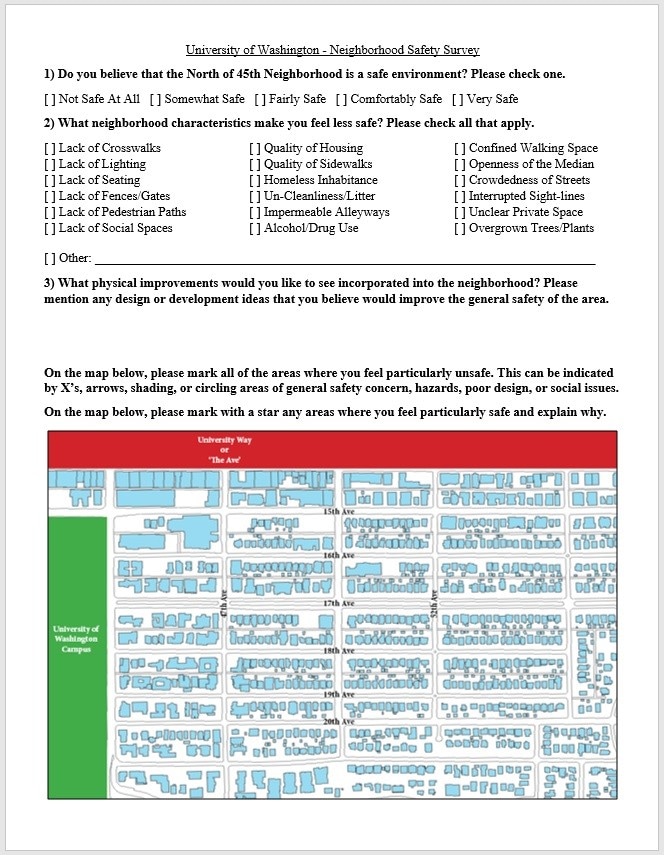
In addition to the aforementioned quantitative review, further research took place by way of qualitative survey data. To effectively narrow my focus and guide my eventual segment evaluation, I developed a survey to gauge the communities’ perspective on crime and safety in the neighborhood. I formulated a brief five-question survey that asked for the level of safety rated on a scale, for the characteristics negatively impacting safety, for personal design changes they wanted to see, for areas where they felt particularly safe, and for areas where they felt unsafe or where crime consistently occurred (Appendix C). I then distributed this survey to local fraternity members, sorority members and community council members. I supplied the survey to members of the Greek system because they live in this immediate context, engage with the site every day, and are therefore presumably most familiar with the common criminal issues. In addition, I gave the survey to a local community council, Ravenna Springs, in order to engage with long standing residents outside of the student population. This distribution method allowed me to synthesize a general safety perspective, from a cross examination of males and females as well as students and adults, by generating an understanding of the most prominent characteristics negatively affecting the safety of the area. The survey resulted in 40 total responses from 20 sorority members, 10 fraternity members, and 10 community council members. The results of this survey was an average safety grade of two out of five, expounding that residents felt the area to be only somewhat safe. I then compiled the data into the most predominant safety inhibiting features. This list helped determine what structural, social, and environmental components the community believed to be hindering safety and promoting crime. Of all the characteristics negatively impacting safety, the issues of lighting and vagrancy were identified as the most predominant. Lastly, I compiled the spatial information regarding zones where people felt unsafe and created a base map of the neighborhood. Collectively, the largest spatial concern was the alley ways running north and south throughout the entire neighborhood. The overlay of responses helped form zones of unsafety that I then targeted in my site assessment.
Fieldwork:
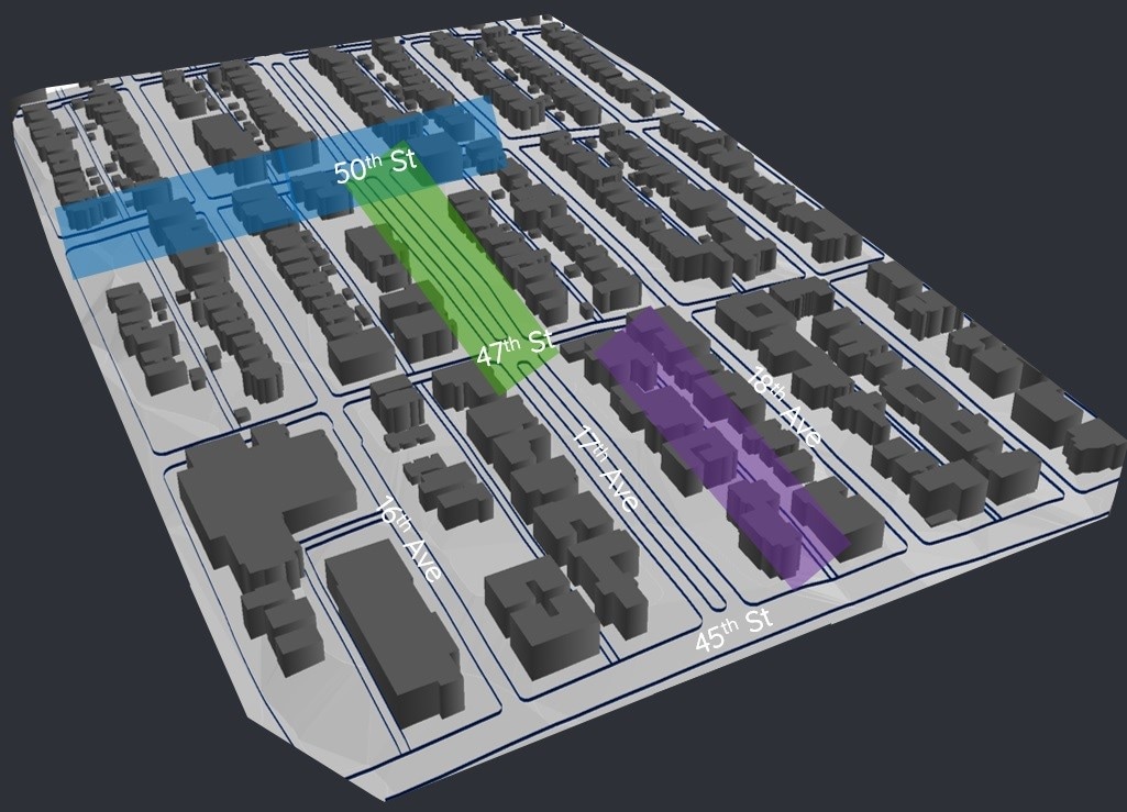
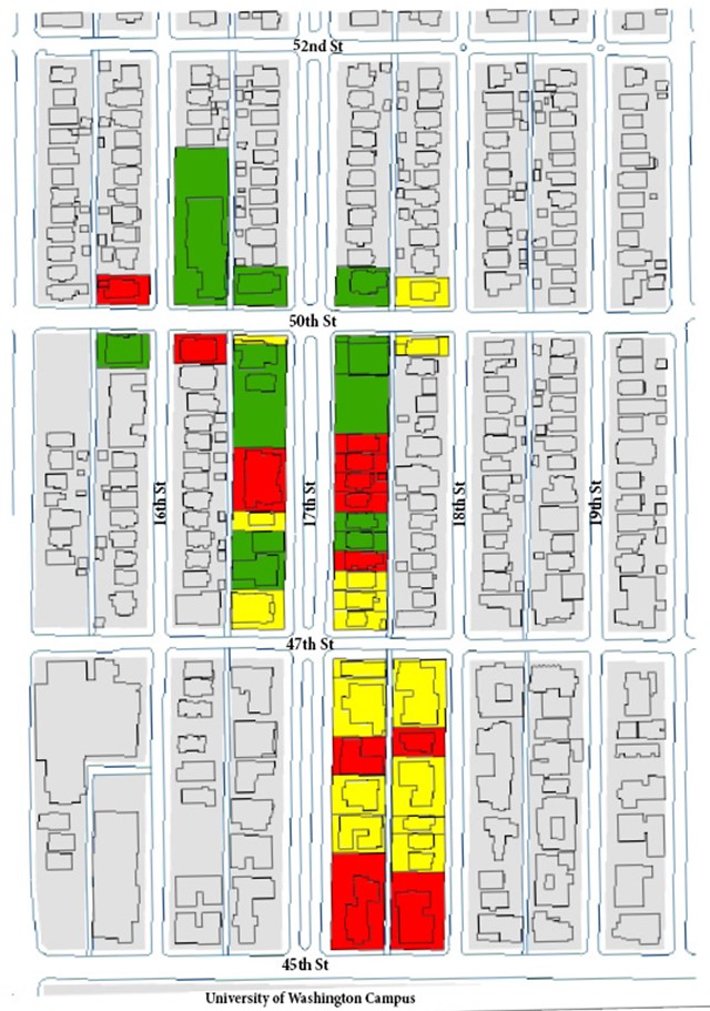
Transitioning from supporting research to the physical site, the fieldwork phase began with the identification of areas to evaluate. From synthesizing the survey data and mapped density responses, I identified several perspective non-safety zones. From these focal zones and main characteristics, I identified three segment types and locations to assess: a core residential street as the segment of 17th street from 50th to 52nd, an alley way as the segment of alley way adjacent to 17th street from 47th to 50th, and a cross street as the segment of 47th from 18th to 19th (Appendix D). The encompassed mixture of street types was to ensure the evaluation of the common elements of the neighborhood and the selection of segments was to assess a wide range of space.
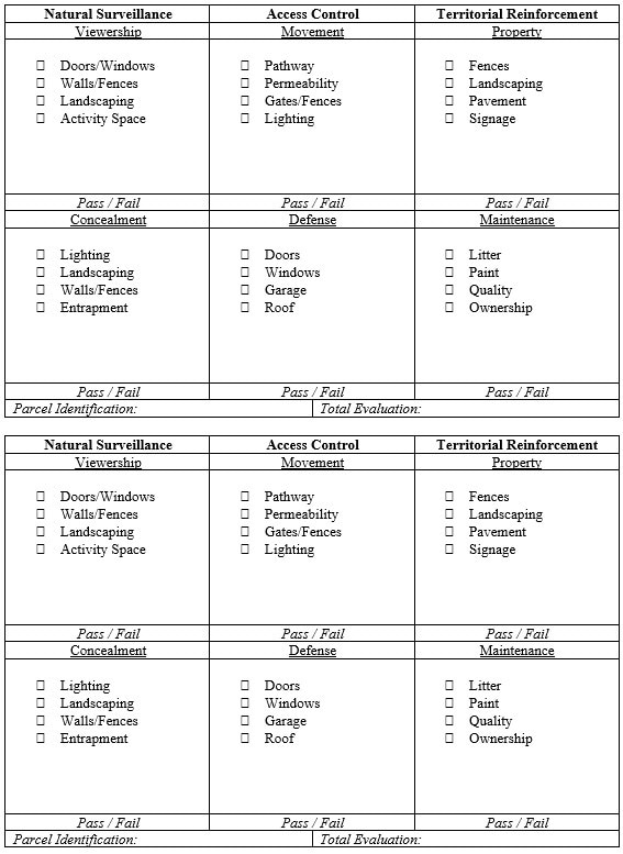
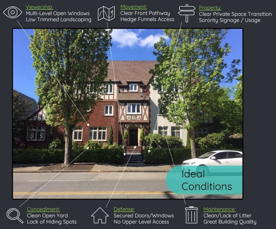
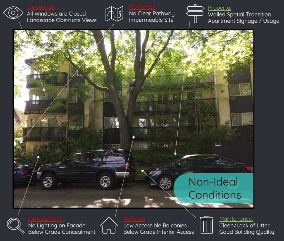
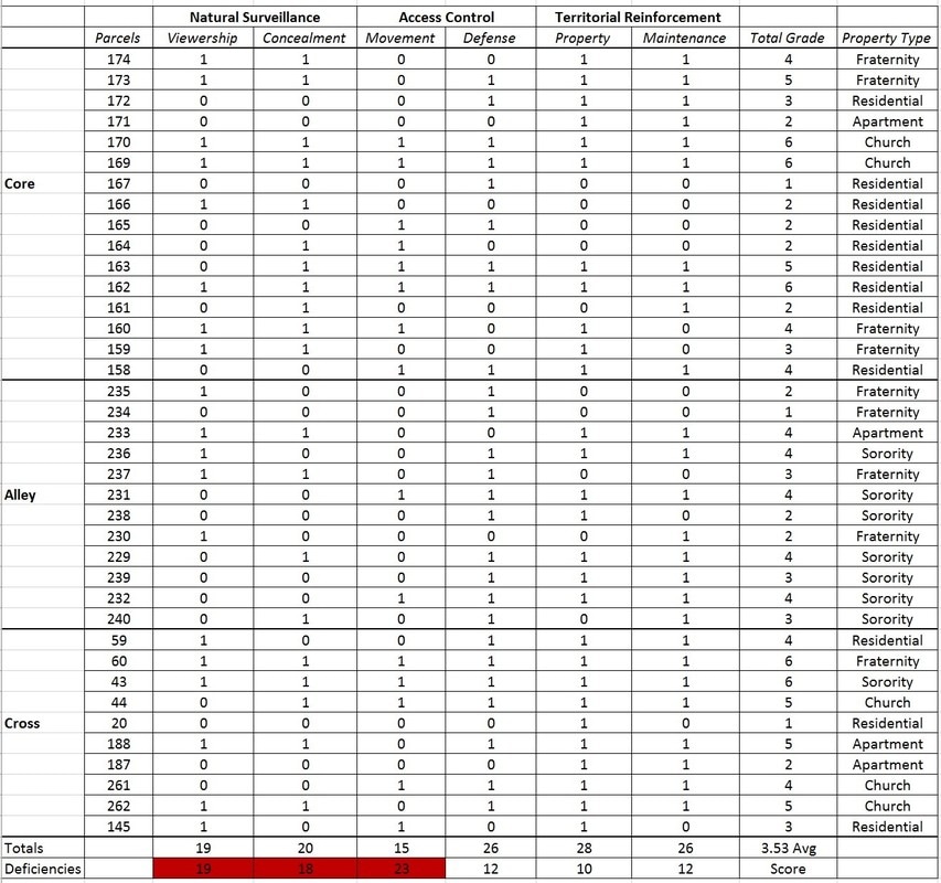
Next, in order to best facilitate detailed grading for every individual parcel along the segments, I established a set of criterion that utilized the three pillars of CPTED: Natural Surveillance, Access Control, and Territorial Reinforcement. In addition, I broke each pillar down into two main components that best represent the guiding principles of their respective pillar: Viewership and Concealment, Movement and Defense, Property and Maintenance. Furthermore, to complete my criteria sheet, I walked around the neighborhood with a University District Partnership employee who is certified in CPTED reviews from the National Crime Prevention Council, in order to understand the specific property characteristics belonging to each component. This culminated in a comprehensive criteria sheet that evaluated the principles of CPTED in a quick and effective manner (Appendix E). The actual segment evaluation process consisted of myself grading each parcel’s façade running parallel to the identified segment. I walked up and down each segment grading each parcel one by one over the course of three days. The grading procedure consisted of checking off positive or negative characteristics listed underneath each of the six individual components of the CPTED criteria and listing notes on the current conditions. Based on the amount of characteristics aligning with the CPTED component, each component was then graded on a pass/fail basis (Appendix F). Therefore, after each of the six components had been evaluated, the overall grade of the parcel was the amount of components that received a passing grade in relation to my CPTED criteria, i.e. 0-6.
After every parcel along the three segments had been graded, the individual assessments were then used to create a map representative of the parcels that are inadequate, relative to CPTED ideology (Appendix G). After visually representing the scores of every parcel, I began to analyze the numerical data in order to identify the most significant CPTED deficits. This process entailed inputting all of the pass/fail results into excel, organized by street segment and individual components. This analysis provided me with the most predominant deficiencies across all three segments (Appendix H). After ascertaining the common negative themes across the neighborhood, I then reorganized the data by property type and component characteristics. This analysis allowed me to accurately diagnose each property type’s main CPTED deficiency as well as the most prominent failing characteristics. These common negative components and characteristics provided me with the basis of deficiencies and needs for the neighborhood to be addressed by my recommendations.
Site Improvement:
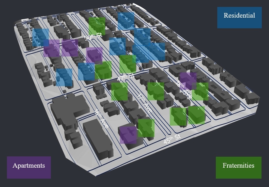
After careful compilation and synthesize of the aforementioned information, I began aligning my data looking for commonalities to address in my recommendations. This took the form of identifying environmental design interventions that directly correlate and respond to the various types of deficiencies discovered as well as the types of crime and community concerns that had been previously revealed. Initially, the common failing components outlined by the CPTED segment evaluation produced the top three most prominent deficiencies. These components were then paired with strategic CPTED applications, outlined in the University District’s CPTED handbook. My proposed recommendations intended to apply to the general needs of the neighborhood in order to contribute to the greater prevention of crime and escalation of safety. Next, in an effort to make my recommendations more specific, I targeted particular property types and their most prevalent failing characteristics. This allowed me to pull individual design changes from the National Crime Prevention Council’s guidebook and pair them to the most pressing property deficiencies. To then supplement the proposals, I generated a map representing the potential spatial reach of CPTED designs, if implemented across each property type (Appendix I). Lastly, in order to support the implementation of the site improvements, I compiled a list of stakeholders invested in the neighborhood and generated three different approaches of outreach, individually developed to foster civic engagement. The full narrative description of my recommendations and next steps, which constitute my product, are featured in the Implications section.
Results
As outlined in my methodology, my neighborhood assessment was composed of evaluations of individual parcel’s facades running parallel to each of the three identified street segments. In total, I evaluated 38 parcels. The property types featured in this evaluation included 4 apartments, 5 churches, 8 sororities, 9 fraternities, and 12 residential homes. The overall average grade for each parcel, in regards to my CPTED criteria, was 3.53 out of a total of 6 or 58%. Meaning that the average property exhibited approximately 3 passing CPTED components, half of the possible total. The following sections provide the statistics resulting from the segment assessment and a narrative analysis of the conditions of each predominant deficiency.
Assessment:
Core Street: The core street evaluation took place on the segment of 17th avenue in-between 47th street and 50th street. This specific assessment included 16 parcels and featured 1 apartment, 2 churches, 0 sororities, 4 fraternities, and 9 residential homes. The average score for this segment was a passing CPTED rating of 3.56 out of 6. Among the failing components, Viewership was the most prevalent.
This street segment is central to the neighborhood and flows directly into campus. It is situated around an Olmstead Parkway, creating a very wide open space median with two streets going either direction around with cars parked on both sides. This segment is most notably characterized by the large trees lining the median and sidewalks, creating a vast canopy cover. The west side of the segment is lined with large structures, a wall of apartments, fraternities, and churches. The east side of the segment is lined with a row of residential homes, all in similar style. The median is very clean and well landscaped while the sidewalks are dirty and broken. At night, the space is extremely dark as the street lights are obstructed by tree branches.
Cross Street: The cross street evaluation took place on the segment of 50th street in-between 15th Avenue and 18th Avenue. This specific assessment included 10 parcels and featured 2 apartments, 3 churches, 1 sorority, 1 fraternity, and 3 residential homes. The average score for this segment was a passing CPTED rating of 4.1 out of 6. Among the failing components, Concealment was the most prevalent.
This street segment is the major cross street transecting the neighborhood. It is a large sloping hill connecting 15th and 20th street and is the main vehicle route as it features the only controlled intersection. This segment is most notably characterized by the lack of pedestrian support. Cars drive at higher speeds and there are few crosswalks to facilitate crossing. Furthermore, this cross street is the main separator of the Greek system and the mostly quiet residential homes further north. This street also features several churches that provide refuge to homeless populations. At night, the street itself is well lit but traveling north or south from this location is extremely dark.
Alley Way: The alley way evaluation took place in the alley formed between the avenues of 17th and 18th and on the segment in-between 45th street and 47th street. This specific assessment included 12 parcels and featured 1 apartment, 0 churches, 7 sororities, 4 fraternities, and 0 residential homes. The average score for this segment was a passing CPTED rating of 3.0 out of 6. Among the failing components, Movement was the most prevalent.
This segment is the typical alley way structure as featured throughout the entire neighborhood. It is lined with a mixture of large fraternity and sorority chapter houses creating a rear narrow corridor. This segment is most notably characterized by overflowing dumpsters and litter, creating a highly neglected space with little activity or viewership. The backs of buildings create large walls with very few windows and the properties string together eliminating access between homes, essentially creating one long pathway. At night, most homes are lit from within and cast large shadows over the alleyway.
Analysis:
Viewership: The criteria component of Viewership is one of the two main components that make up the CPTED pillar of Natural Surveillance. After compiling the pass/fail scores for each component and each parcel across all three segments, Viewership accounted for 19 failing grades out of 38 total scores. This is the result of properties across the neighborhood having obstructed sightlines from inside of the home and property to the public right of way and street’s edge. These obstructions were multifarious, composed of doors and windows being closed and cluttered as well as walls and fences impeding all viewership from in or out of the property. In addition, natural landscape components were often overgrown, covering windows, or entirely concealing whole properties. These characteristics, in opposition to the CPTED public space theory of deterring crime through consistent vision, make Viewership a major deficiency in this neighborhood.
Concealment: The criteria component of Concealment is the second component that make up the CPTED pillar of Natural Surveillance. After compiling the pass/fail scores for each component and each parcel across all three segments, Concealment accounted for 18 failing grades out of 38 total scores. This is the result of properties across the neighborhood possessing an abundance of concealed spaces and large dark unmonitored areas. These conditions were evidenced by a massive lack of lighting. The city street lighting throughout this neighborhood is largely spaced and obstructed by canopy cover. In conjunction, individual properties exhibited a sheer lack of outdoor lighting over their façade or property. In addition, uncontrolled landscaping paired with high impermeable fencing created an abundance of spaces shadowed or concealed from the street. These characteristics, in opposition to the CPTED public space theory of deterring crime through seeing and being seen, make Concealment a major deficiency in this neighborhood.
Movement: The criteria component of Movement is one of the two main components that make up the CPTED pillar of Access Control. After compiling the pass/fail scores for each component and each parcel across all three segments, Movement accounted for 23 failing grades out of 38 total scores, the most of all deficiencies. This is the result of properties across the neighborhood neglecting to facilitate movement throughout their parcels. The two predominant characteristics causing this result are the lack of delineated pathways and excess of impermeability. Of all parcels evaluated, most lacked pathways to guide movement to and from access points; neglecting to include pavement, fencing, landscaping or lighting to guide appropriate access. In addition, most properties structure or fencing walled off the space entirely, creating barriers rather than improving circulation. These characteristics, in opposition to the CPTED public space theory of deterring crime through controlling access, make Movement a major deficiency in this neighborhood.
In summation, my CPTED evaluation of neighborhood segments revealed that Viewership, Concealment, and Movement were the area’s largest deficiencies. Reviewing all of the data from my research and field work, the results of my CPTED evaluation seemed to accurately align with the communities’ concerns and the types of crime happening in the district. The deficiency of Viewership, aided by the overall lack of lighting described by the community, allows for an abundance of dark unmonitored spaces where assaults could take place. Moreover, the large quantity of Concealment points facilitates vagrancy and larceny. Furthermore, the lack of controlled Movement, especially in conjunction with alleyways, allows for muggings or robbery to take place without adequate escapeability or alternate routes. Although only conjecture, the alignment of these phenomena support the correlation between CPTED theory and crime; revealing deficiencies within the design of the natural and built environment that are conducive to criminal behavior.
Implications
Recommendations:
Neighborhood Interventions: As stated in my purpose, I wanted to provide residents of the community with small tactical design improvements that they could take upon themselves to implement to help address the types of crime and concerns within the area. To accomplish this task, below are generalized recommendations corresponding to each of the neighborhood’s CPTED deficiencies.
Viewership: The key to improving Viewership is by un-obstructing sightlines. Most simply, this can be addressed by leaving upper level window curtains open and clearing windowsills, creating the perception that someone could be looking out at any moment. Next, is implementing external lighting as viewership can’t take place if the area is too dark. This means applying lights to the façade of the building that face forward and illuminate the space, creating a well-lit zone for viewership in and out of the property. Lastly, to improve Viewership, I recommend trimming or designing landscaping in such a way as to un-impede sightlines and un-obstruct light rays.
Concealment: The most effective way to decrease areas of Concealment is to limit the structural proponents creating these spaces. Most simply, this can be supported through the planting of prickly vegetation. Landscaping, such as roses, sticker bushes, or holly are great at filling gaps in concealed areas as they deter hiding. Next, the best scenario is to lock or light small building inlets or confined spaces. This means adding small outdoor lights or padlocks to areas concealed from public view. Lastly, to improve Concealment, I recommend lining properties with see-through fencing. Cast iron fencing is a perfect solution to concealed properties because it provides clear private space and security while allowing visibility and decreasing the possibility of hiding or entrapment.
Movement: The best way to facilitate Movement is by clearly directing traffic flow. Most simply, this can be achieved through the implementation of signage. Different types of signage can be added to properties to clearly identify whose allowed access, where to access the property, and what behavior is appropriate within the space. The next important design intervention is utilizing pavement changes or landscaping outlines to create clear pathways throughout the property. This means delineating pathways to direct movement to and from access points as well as around the property. Lastly, to improve Movement, I recommend lining property boundaries with low fencing or landscaping to effectively funnel access through specific portals.
Property Interventions: As outlined in my methodology, in an effort to make my recommendations more specific and strategic, I scaled them down to particular design changes geared toward the failing characteristics and specific function of individual property types. From the neighborhood findings, I took my evaluation a step further and analyzed the data by property type. Once separated, I identified the particular characteristics that were failing the most. This analysis revealed that churches and sororities performed very well across the board in regards to CPTED, both possessing no outstanding failing characteristics. However, Apartments were consistently failing to provide activity space and effective lighting. For Fraternities, both of their main issues dealt with movement, as the sites were not permeable and movement was not supported by lighting. And Residential Homes’ most prevalent deficiencies were doors and windows being obstructed and gates and fences ineffectively directing movement. In order to illuminate the potential of CPTED, I wanted to provide small, simple, and strategic design interventions directly to property owners. To accomplish this task, below are explicit recommendations corresponding to each of the neighborhood’s property types.
Residential: For Residential Homes, deficient in viewership and movement, I recommend implementing fencing and landscaping that adheres to the 3ft/7ft rule. This means implementing or restricting fencing to 3ft high and tree cover trimmed to 7ft off of the ground. This technique directs movement to and from the home while offering a wide viewshed from the interior.
Fraternities: For Fraternities, making up the bulk of alley way properties and needing to be accessible at all times of the night, I recommend implementing external pathways and motion sensor lighting. This means designing external pathways that flow to and from access points but also flow around the buildings, effectively creating alternate routes and escape paths from the alley corridors. Moreover, applying motion sensor lighting along those pathways guides appropriate users toward entrances when need be but deters usage otherwise.
Apartments: For Apartments, lacking in activity space and lighting, I recommend designing in common areas and increasing peripheral lighting. Apartments, housing the largest populations under one roof, have the best chance at increasing natural surveillance for the community. To foster this phenomena, designing and implementing parklets, cabanas, or play-areas provide space for people to congregate and offer eyes on the street. In addition, for these large structures with an abundance of inlets, adding lighting over the façade can help eliminate concealment. Furthermore, increasing lighting but decreasing wattage allows for large well-lit spaces but doesn’t cast sharp shadows.
Implementation:
In order to facilitate the recommendations I have provided for the neighborhood, I have compiled a list of local stakeholders and established phased periods of potential implementation. My next steps will be to recapitulate my research, evaluations, and recommendations, pair them with the developed list of stakeholders and implementation periods, and pass everything along to my internship advisors. My internship, the Husky Neighborhood Program, deals directly with community development and civic engagement within the North of 45th neighborhood. Therefore, passing along my investigation coupled with outlined instructions on how to proceed; will provide next year’s neighborhood interns with projects and starting points on how to address, educate, and implement these findings to deter the current criminal conditions of the community.
Short Term: To begin this improvement process, next year’s Husky Neighborhood Interns should engage with local community groups in order to work together to initiate small tactical design changes. To best facilitate this task, the interns should target large collective community groups such as Fraternities, Sororities, and Churches. These communities offer pools of potential volunteers, invested in their neighborhood, and easy to reach in large numbers. Within my study area boundaries alone, there are 22 fraternities, 15 sororities, and 7 religious communities. The abundance of these groups provide a wide reach throughout the community and possess their own pools of funding; making implementing things like façade lighting, pathways, and signage easy to achieve. Reaching out to these entities, engaging them in community activism, and guiding them towards simple design changes could be significant first step towards improving the neighborhood.
Intermediate: The next step in applying neighborhood improvements is to engage and educate community councils, apartment landlords, and police departments. Once again, each entity is a large easy to reach grouping, however each have different potential contributions to the whole neighborhood effort. Fraternities and Sororities have constant turnover which makes it difficult to garner consistent engagement. To address this discrepancy, the long standing residents within the neighborhood need to be educated about the theory of CPTED, its principles, and how specific designs can impact the behavior around them. With Fraternities, Sororities, and Churches being directed to implement immediate design interventions, permanent residents can begin to enact CPTED designs within their own individual properties. In addition, several apartments are scattered throughout the neighborhood and more multifamily housing units are popping up constantly. Consequently, engaging landlords or property owners, provides opportunities to disseminate information and employ CPTED designs before these large buildings are constructed. Lastly, a tactic to spread more CPTED practices directly to areas or peoples dealing with criminal issues is to encourage the Seattle and University Police Departments to educate and circulate design changes when responding to crimes in the neighborhood.
Long Term: The final stage in my implementation plan deals with long term goals for the interns and community to strive for. After employing community groups to enact design recommendations as well as educating and encouraging permanent residents to do the same, the long term goal for neighborhood improvement is to establish partnerships with the large local institutions. This can be achieved through connecting with the University District Partnerships. They retain a Clean and Safe Committee that provides certified CPTED reviews and consistently host volunteer events to improve the neighborhood. Additionally, requesting that the University itself increases their role within the neighborhood could be a monumental step towards organizing and facilitating community enhancement. The University owns a lot of the Greek houses in the neighborhood and depends upon this space to house a large number of students. Therefore, helping the University realize the role CPTED principles could play in improving the safety of their students could persuade them to take more ownership of the area. The best case scenario for this type of partnership would be for the University to support the maintenance and management of community projects and overall cleanliness. Furthermore, to cap off this neighborhood improvement progression, the City of Seattle should be used to leverage funding for community development projects. CPTED principles can be affective in deterring criminal behavior and communities can have total buy-in, however, personally paying for design changes often discourages and prevents implementation. The solution to this issue could be found in the City of Seattle’s, Department of Neighborhoods. They provide a grant program that offers Small Sparks Funds (up to $5,000) and Community Partnership Funds (up to $100,000) which can be used to hire personnel and professional services as well as pay for materials and construction. Utilizing a combination of the aforementioned resources could go a long way in enacting structural change and improving community conditions at the neighborhood scale.
Conclusion
Critique:
The course of this investigation over the past nine months has been an immense amount of work. However, this project has provided me the invaluable experience of planning, creating, completing, and presenting a long term mission all by myself. Throughout these long months and project phases, I have arrived at three primary takeaways. The first of which is that the theory of Crime Prevention Through Environmental Design is extremely flexible and relative to the different characteristics and scales its being applied to. My project’s goal was to ultimately provide simple design recommendations for the community that strategically correspond to the issues and deficiencies in the neighborhood. I believe I have achieved clearly building a connection between types of crime and CPTED practices, however the actual recommendation component has been lackluster. My project attempted to target highly applicable recommendations but found it exceedingly difficult as every parcel is its own case by case basis.
In addition to the wide variance of property conditions, recommending design interventions was challenging due to the contradictory nature of CPTED components. My project centered around six ideal conditions of CPTED, Viewership, Concealment, Movement, Defense, Property, and Maintenance and I found it extremely difficult finding homes that closely adhered to every single principle. Ultimately, it can be argued that the ideology behind each component can function in contradiction to the other elements. Examples of this can be found when attempting to unite such characteristics as lighting up your property to support viewership while also defending access into your home. Or when endeavoring to combine access control to facilitate movement within your property while also concerned with decreasing areas of concealment. Likewise, it is particularly problematic trying to implement designs that connect private properties to the street and public space. A large population of homeowners much prefer living within private defensible spaces and don’t feel safe using their homes to influence the behavior of public interactions.
Moreover, a major critique of my project is the neglect of the highly social component of CPTED. Being a design student, highly interested in the development of urban design and planning, I really narrowed my focus to strictly evaluating and recommending design components. Although more personally stimulating, the design features would have been further strengthened and supported by the incorporation of CPTED social components. I believe that simple and strategic design changes can effectively influence criminal behavior, however, a large part of CPTED’s efficiency is through community engagement and understanding. Therefore, if I were to do this project differently, I would make it a point to incorporate recommendations targeting social cues and behaviors to reinforce CPTED theory. Examples of this would be highlighting how public congregation enhances eyes on the street, how conscious pathway decisions improves access control, and how ownership and maintenance enriches territorial reinforcement.
In conclusion, although the final proposed designs were difficult to determine, lacking a social element, and may not directly prevent crime from happening; they do provide small scale interventions that when paired with enough community support, could go a long way in engaging communities and collectively deterring negative behavior across entire neighborhoods.
Reflection:
Echoing the aforesaid critique, my one regret from this project has been my personal pressure of generating pure design interventions. When developing the idea for my capstone, my initial intention was to produce graphics and 3D models demonstrating my urban design recommendations. However, I quickly realized that CPTED is largely comprised of theory and only loosely correlates to anything I would qualify as design interventions. Yet, throughout my process I kept trying to force this design narrative because it’s what I was interested in the most. I believe if I would have let my project breathe a little and stray from the design course, I could have developed much more in-depth recommendations for the community. Nevertheless, this project taught me that urban design can’t be enacted like a blanket, covering a multitude of issues and characteristics with one overarching idea; but instead must be patched together, harnessing the power of individual components of an already established urban framework.
Arriving at the culmination of my capstone, I feel exhausted yet extremely satisfied and proud; satisfaction arising from the comprehensive completion of my project and pride emanating from the success of spearheading my own idea and investigation. In its entirety, this venture offered me a chance to engage with communities and work towards the betterment of something much greater than myself. More specifically, this project provided me with the opportunity to expand my awareness and understanding of space and its influence on social behavior. Overall, these lessons learned and skills gained will greatly benefit me on my pathway to becoming an Urban Planner and Designer.
My primary takeaway from this entire process as it relates to my personal growth is relatively simple. I know who I am as a student and I know who I am as a worker. However, this project effectually brought out the best of both of my skillsets and combined them, helping me mature into a professional. Wherever life takes me in the next stage of my career, I will look back on this project and find confidence in the fact that I have truly evolved from a young scholar to a qualified professional; capable of managing large scale projects and truly dedicated to the field of urban design and development. In closing, the opportunity to engineer and execute a long term research project at an institution such as the University of Washington has been a truly captivating experience comprised of intellectual exploration and personal growth.
Bibliography
Bell, Wendy. CPTED and Urbanism: Some Tensions. Rep. Adelaide: International CPTED Association, 2014. Print.
Cheong, Chong, and Benedict Tan, comps. Crime Prevention Through Environmental Design Guidebook. Publication. Singapore: National Crime Prevention Council, 2003. Print.
City of Portland. Neighborhood Involvement. Crime Prevention Through Environmental Design. United States: n.p., 2015. Print.
Clarke, Ronald. The Theory of Crime Prevention Through Environmental Design. Rep. Tampa: Center for Urban Transporation Research, 2000. Print.
Cozens, Paul, and Terence Love. "A Review and Current Status of Crime Prevention through Environmental Design." Journal of Planning Literature 30 (2015): 393-412. Web.
Crowe, Timothy, and Diane Zahm. "Crime Prevention Through Environmental Design." National Association of Home Builders: Land Development 1994: 22-27. Web.
Foronda, Rogelio, Jr. Addressing Crime Through Urban Design and Programming. San Jose State University, 2015. Web.
"Friends of the ICA." Crime Prevention Through Environmental Design. International CPTED Association, n.d. Web. 22 Jan. 2017. <http://www.cpted.net/>.
Jacobs, Jane. The Death and Life of Great American Cities. New York: Random House, n.d. Print.
Johnson, Marcus. CPTED for Single Family Housing. Seattle: U-District Partnership, 2012. Print.
Jusiewicz, David. Crime Prevention Through Environmental Design: Crime Free Multi-Housing. Rep. U of Texas at Arlington, 2011. Print.
Newman, Oscar. Creating Defensible Space. Washington, D.C.: U.S. Dept. of Housing and Urban Development, 1996. Print.
O'Toole, Kathleen. "Data Driven." Crime Dashboard. Seattle Police Department, 30 Apr. 2017. Web.
Redland City Council. Planning & Development. Safer By Design. 5th ed. Australia: n.p., n.d. Print. Policy 16.
Sohn, Dong-Wook. “Assessing the Effectiveness of Crime Prevention Through Environmental Design.” Cities 52 (2015): 86-93. Elsevier. Web.
Appendices
Appendix A:
Appendix B:
|

|
Appendix C:
Appendix D:
Appendix E:
Appendix F:
Appendix G:
Appendix H:
Appendix I: